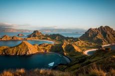
The Pacific island nation of Vanuatu is a remote destination in Melanesia that offers diverse diving on reefs, wrecks and in freshwater springs that are home to a number of endemic species. Pierre Constant shares his adventure there.

Contributed by
It was a long way from Europe to Vanuatu (formerly the New Hebrides) in the western Pacific Ocean. The Air France flight from Paris took me to Tokyo, where I had to change to an Air Calin flight to Noumea in New Caledonia. When I arrived there two days later, just before midnight, I was jet-lagged—only to discover, with a sigh and some stupor, that one of my checked bags had not appeared on the conveyor belt. Air Calin did not track bags on their computers. Of course, their agents were keen to hand me a “lost” claim form swiftly, so they could get rid of me with a smile.
With a flight to Vanuatu two days later, I was rather stressed. But with a Zen attitude, I tried to get some sleep. The next morning, there was no word from either Air France or Air Calin, who were responsible for my luggage. Late in the afternoon, my luggage was finally delivered to the hotel. Apparently, another passenger had picked up my bag by mistake and returned it to Air Calin, without so much as a note of apology. The next day, I flew to Port Vila on schedule on an Air Calin flight operated by Air Vanuatu. Frustratingly, I had to pay 22kg in excess baggage fees for my second bag. My trip had definitely gotten off to a hectic start.
About Vanuatu
Located in a time zone 11 hours ahead of UTC, the Y-shaped archipelago of Vanuatu has a total land area of 12,274 sq km and a population of 336,000. It stretches 1,300 km from northwest to southeast and consists of 83 islands. The largest are Espiritu Santo (3,959 sq km), Malakula (2,069 sq km), Efate (980 sq km), Erromango (900 sq km), Ambrym (682 sq km) and Tanna (550 sq km). Mount Tabwemasana on Espiritu Santo is the highest point, with an elevation of 1,879m.
Located in the Southern Hemisphere between New Caledonia and the Solomon Islands, Vanuatu lies between 13°S and 21°S latitude and 166°E to 171°E longitude. It is part of the Australasia-Melanesia region, which includes New Caledonia, Solomon Islands, New Guinea, Fiji, Australia and New Zealand.
Part of the Pacific Ring of Fire, the islands of Vanuatu are of volcanic origin. Due to the tectonic subduction of the Indo-Australian Plate under the Pacific Plate, the first and largest islands of Espiritu Santo, Malakuka and the Torres Group emerged from the ocean on the Pacific Plate 22 million years ago. The younger islands rose up less than five million years ago.
The slow uplift, combined with the formation of fringing coral reefs, means that many of the smaller islands are composed of coral limestone. The eastern half of Santo consists of uplifted Pleistocene coralline limestone covering a land area of 1,600 sq km. It is a region of many caves and subterranean rivers. Coral terraces and flat coralline islands are common. Vanuatu also has nine active volcanoes, seven on land and two underwater. These include Lopevi (Efate), Mount Yasur (Tanna Island), Mount Garet (Gaua Island), two volcanoes on Ambrym Island and Ambae Volcano. An undersea eruption was recorded in November 2008, with an earthquake measuring 6.4 on the Richter scale.
Prehistoric migrations
For the modern archaeologist (Jean Christophe Galipaud, IRD 2006), the settlement of the Pacific region was the result of two distinct migrations. The first one, which took place during the Pleistocene epoch 80,000 years ago, concerns the Australian continent, New Guinea and the adjacent archipelagos. In the past, these areas were united in a single landmass known as Sahul. There is evidence of human presence in New Guinea 40,000 years ago and in the Bismarck Archipelago 10,000 years later. Past existing land bridges allowed further migration to reach Guadalcanal in the Solomon Islands.
The second migration is associated with small mobile groups of skilled seafarers originating from Southeast Asia and Taiwan, who appeared in the Bismarck Archipelago 3,500 years ago. They quickly spread to remote Oceanian archipelagoes to the south and east, reaching New Caledonia, Samoa and Tonga 3,000 years ago. There is evidence of their presence in the Santa Cruz Islands (north of Vanuatu) 3,200 years ago, and the distinctive pottery they left is known as “Lapita.” Austronesian languages, spoken only in remote Oceania, are associated with the Lapita diaspora.
Early settlements in Vanuatu include those on small offshore islands south of Santo (Aore, Malo), northern Malakula, Efate and Erromango. A characteristic of Lapita pottery was that it was richly decorated. Stunning examples can be seen in the National Museum of Vanuatu in Port Vila.
The early navigators introduced plants, such as edible nut-bearing trees, banana trees, taro and yam. Animals they introduced to Vanuatu included the Pacific rat, chickens, dogs and much later, pigs. An area buried under one metre of sediment at the site of Makué (in northern Aore Island) and excavated in 2002-2006, revealed a seasonal camp for sailors from the Bismarck Archipelago, with many obsidian flakes found that could be traced to the region of Talasea in New Britain (in Papua New Guinea) as well as marine turtles and shell remains.
European contact
The first European contact was made by the Portuguese explorer Pedro Fernandes de Queiros, who sailed for the Spanish crown in April 1606. In search of Terra Australis, he passed by the Banks Islands, then called Espiritu Santo, which he believed to be Australia. The settlement at Big Bay was abandoned after a month, due to poor treatment of the natives and ill health of the crew. French explorer Louis Antoine de Bougainville visited in May 1768 and landed at Ambae, where his men were attacked.
In July-September 1774, James Cook explored the islands, which he christened the New Hebrides, a name that stuck until Vanuatu claimed independence. After the mutiny on the HMS Bounty in 1789, Captain William Bligh and the rest of his crew sailed through the Banks Islands. Whaling ships made ports of call at Vanuatu between 1804 and 1887, followed by traders seeking sandalwood in Erromango.
Planters from Australia, Fiji and New Caledonia came to Vanuatu in the 1860s in search of laborers. They were known as “blackbirders” and associated with the shameful slave trade and exploitation of the indigenous people. Exposed to poor health and foreign diseases, many Ni-Vanuatu perished. Blackbirding was banned in Australia in 1906.
Roman Catholic and Protestant missionaries from the London Missionary Society and the Anglican Melanesian Mission travelled to Vanuatu from 1839 onwards. French planters colonized Efate in 1880, leading to the establishment of the Compagnie Calédonienne des Nouvelles Hébrides’ (CCNH) by pro-French Irishman John Higginson. The French government took over the company in 1894. Consequently, French and British interests came into conflict in what became known as the “Anglo-French Condominium,” leading to an agreement for joint administration of the islands.
In the 1920s and 1930s, Vietnamese workers were brought in from French Indochina to work on the plantations of the New Hebrides. As many as 6,000 were imported.
With the advent of World War II, Britain gained a greater degree of authority. The Australian military stationed a 2,000-strong force at Malakula. Fearing a Japanese invasion of Australia, the United States joined the effort, coming to the rescue in 1942 and establishing bases at Efate and Santo. With the reoccupation of the Solomon Islands in 1943, the Americans withdrew in 1945.
After the war, cattle ranching led to extensive clearing of the Ni-Vanuatu “kastom” or traditional lands. Initiated by Chief Buluk of Big Bay and Ni-Vanuatu nationalist politician Jimmy Stevens, the Nagriamel Movement opposed this abuse and pushed for Ni-Vanuatu-led economic development. Slowly, new parties emerged, paving the way for independence in 1980.
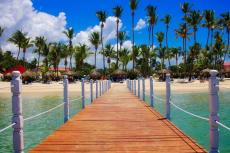
Diving at Port Vila
Port Vila is the capital of Vanuatu and the main city in the southwest of Efate Island. The international airport is located just north of the city. Diving takes place in Mele Bay, between Devil’s Point to the west and Pango Point to the south. The small dive centre is located right on the waterfront, on the scenic promenade of the tourist area.
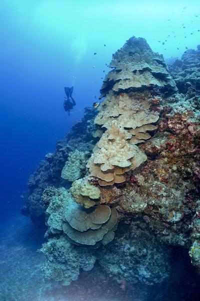
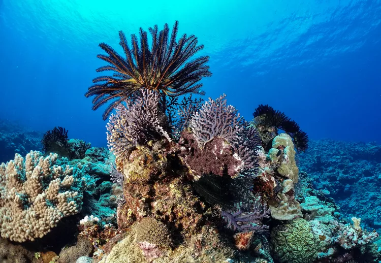
Kathleen’s Reef and Abyss. The dive boat took me on a 15-minute ride to the dive site of Kathleen’s Reef. It was a coral mound with blue water and great visibility. But a thought flashed through my mind: Where are all the fish? The site looked deserted, although I did encounter a small school of bignose unicorns (Naso vlamingii), with a few fusiliers in the shallows. The nearby site of Abyss also had little fish life, but the hard coral colonies were impressive, consisting of staghorn coral, large plates of table coral, and bubble coral. The water temperature was a warm 28°C.
Cathedral. The next day I wanted to dive at Cathedral and Twin Bommies, which had been recommended by one of the older dive guides at the dive centre. The first site was at Pango Point, where a strong swell was pounding the reef. Underwater, the visibility was cloudy with lots of sand and particles stirred up. The twist here was a vertical cleft in the reef structure that led to a cave that one entered at a depth of 22m. The idea was to go up into a chimney to a round pool below the surface. In good conditions, this offered great photographic opportunities. Today, the water currents were too erratic. Half-way up, we turned back. It was too risky.
Twin Bommies. Twin Bommies, on the southeast side of the bay, was a scenic dive featuring a diverse coral garden with many hard corals. A giant fluted clam (Tridacna squamosa) was nestled on the edge of the drop-off, which was carved with many caves, hosting Spondylus oysters, little schools of red soldierfish, a mimic (fire) surgeonfish (Acanthurus pyroferus), a marbled or black-blotched porcupinefish (Diodon liturosus) and the oriental sweetlips (Plectorhinchus vittatus).
Wrecks
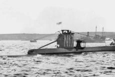
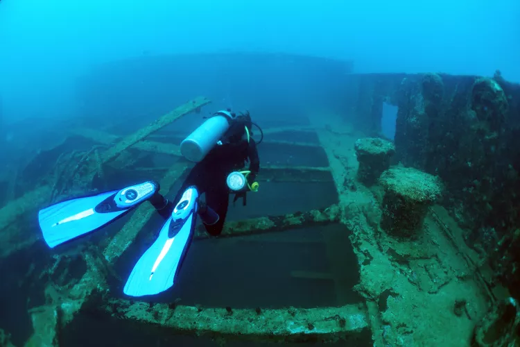
Star of Russia. Mele Bay is also known for a couple of wrecks. The most famous one is the Star of Russia. Originally a fully rigged American transport sailing ship built by Harland & Wolff, Ltd. in Belfast in 1874, it was 84m long, 12.3m wide, with three masts and a gross tonnage of 1,981 tons. It was used to transport jute from India to Europe, as well as goods to Australia, where it carried many migrants. Later it was reported to carry coal, wheat and even cement.
Its maiden voyage was on 5 April 1875. In the course of its life, the ship was sold to a few owners, such as the Burns Philp Company in Sydney (1926-1930) and then to French owners. Renamed Bougainville, the ship was sent to New Caledonia, where it served as a barge. Eventually, the Star of Russia ended up in Port Vila, as a floating warehouse and a copra hulk. It sank in 1953 northwest of the main wharf and now lies in 35m of water, upright and facing south.
When I dived on this wreck with Ni-Vanuatu dive guide David, the visibility was not clear. A school of bigeye jacks swirled above, which I took as a sign of welcome. Barracudas silhouetted in the distance were rather shy. A school of yellowback fusiliers (Caesio teres) cruised past. When I reached the deck, I noticed that the wooden decking had been eaten away. All the steel joists were still in place and the hull looked like a giant skeleton.
Suddenly, David pointed to a nudibranch on a metal beam. Black in colour, with an electric blue line across the front and a blue girdle, it was a Tambja morosa. Just my luck! I changed the wide-angle lens on my camera to a macro lens. Zooming in on the creature, it suddenly stood on its foot, facing me, sensing me with its little rhinophores. It was a magical moment of silent communication. Fish life seen on the wreck included the silver (gold spotted) sweetlips (Plectorhinchus flavomaculatus) and blacktail snapper (Lutjanus fulvus).
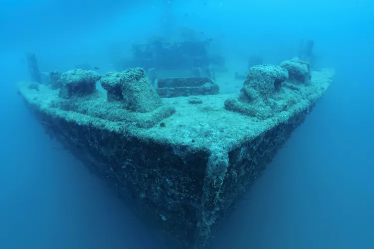
MV Konanda. Another wreck worth considering is the MV Konanda. It was launched on 20 January 1955, from the D&J Boot shipyard in Alphen, on the River Rhine in the Netherlands. Built for the Adelaide Steamship Company, it was 51m long, 9m wide and had a tonnage of 414 gross tons. It was put into service carrying raw sugar between Cairns, Mourilyan and Goondi in Queensland.
In 1961, it served as a ferry between Nelson and Wellington in New Zealand. Sold to Captain Athol Rusden of Port Vila, the ship was used around Vanuatu and other South Pacific islands, sometime after 1967. On 7 February 1987, the ship was struck by Cyclone Uma and declared a total loss. In November of the same year, it was scuttled off the island of Ifira, not far from Port Vila’s harbour.
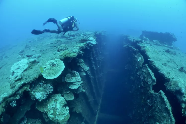
The wreck faces south and sits in 26m of water. There are two holds aft of the bow. Penetration can be made through a starboard door, via a large cabin on the port side. The bow is above. A large school of orange fin or longfin batfish (Platax pinnatus) cruised back and forth under the bow. Maximum depth was 27m, for a dive time of 33 minutes.
Office. On my last day of diving, I was taken out of Mele Bay, beyond Pango Point, to a site called Office. At last, I felt a difference, fish were again to be seen in a maze of canyons and channels. I saw a large school of longfin batfish and a school of bohar or red snapper (Lutjanus bohar). Two grey reef sharks appeared shyly, keeping their distance.
A tunnel-like swim-through, with a bent bean shape and double entrance, lent itself to a wide-angle shot. An inquisitive school of bluefin jacks (Caranx melampygus) swam by. A strong southward current was felt at the end of the dive. On surfacing, I found the boatman far away!
My last dive was disappointing; the coral reef was dead and overgrown with reddish-brown filamentous algae. There was no fish life at all, but crown-of-thorns starfish (Acanthaster planci) were hard at work, destroying the reef. The joke of it all: The dive site was named “Awesome”!
Impressions
After ten dives in Port Vila, my conclusion was grim. Mele Bay had been fished out. Unfortunately, the dive centres do not tell you this, as long as they can sell you dive packages and make some money. It felt like a “booby trap.” On the second day of my arrival in Port Vila, a 1,000-passenger Royal Caribbean cruise ship arrived to drop anchor in Mele Bay for a couple of days. It was clear to me that big business was coming to Vanuatu.
Topside excursions
When not diving, there are some topside excursions worth doing in Efate. I had read about a historic cave on Lelepa Island. As a bonafide “cave man,” it was of interest to me. “I know a guide who could take you [there],” said David, the dive guide.
We met the fellow the next day as he was racing through the harbour in a speedboat. “It will cost you VUV 9,000 (about US$78),” he exclaimed. “But I am not free on Monday.” No thank you, I thought.
So, I asked a French-speaking Ni-Vanuatu resident about the “local way” to get to the cave. “You catch a minibus to Au Bon Marché Manples, change to another, heading north to Lelepa Landing, then cross by boat over to Lelepa Island,” said the local. “In [the village of] Natapao, head left along the coast and walk for 20 minutes… You’ll find Fele’s Cave [there].” So, I did.
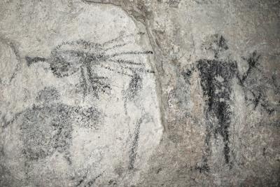
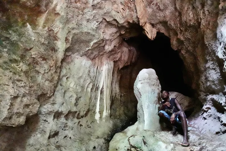
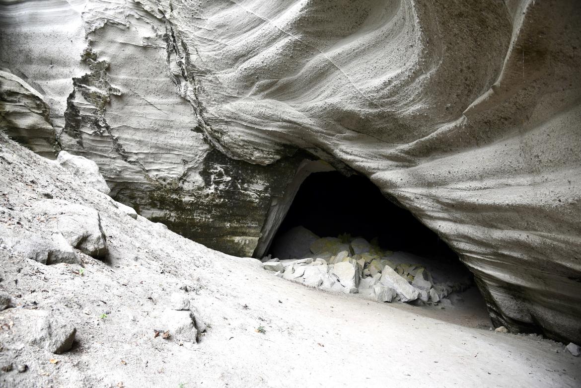
In the village, a woman pointed me in the right direction. “You’ll find people there!” she assured me. I strolled through the coastal forest, fringed with pandanus trees, and suddenly found myself at the foot of a 40m-high cliff of white volcanic ash with undulating layers. It was an eerie place. Not a single soul around. With a headlamp on my forehead, I ventured inside, between large fallen boulders, in a clockwise direction.
There I found a vast round chamber with a high conical ceiling. It was here that Chief Roy Mata was killed by his brother in the 13th century. As a taboo place, speaking was not allowed. At first, I found nothing but lines of carved small holes in the wall and lines of short black bars made with charcoal underneath. It was “a 3,000-year-old lunar calendar,” I was later told.
As I retraced my steps back to the entrance, I discovered trochus and clam shells on the floor. A fossilised nautilus shell was stuck under a ledge. Finally, to the left of the entrance, black charcoal drawings appeared, including the figure of a whale (a symbol of good luck, announcing the start of the yam planting season), a chicken (for catching fish) and an anthropomorphic figure with raised arms, attributed to Chief Roy Mata himself.
Back in the village, the rain poured down. I took shelter under the house of Manu, the boatman, was offered papaya by his daughter Samantha and had a lovely chat with the family. They organised tours around the island.
On to Luganville
Being a dedicated diver and travelling “light” with diving and underwater photography equipment in tow, flying between the islands was not an option considering the high cost of domestic flights—not to mention the excess baggage fees. So, I had to take the Vanuatu Ferry from Port Vila to Luganville on Espiritu Santo. The 24-hour crossing was via Malakula Island, further north.
Check-in was supposed to be at 10:00 a.m., but did not actually occur until 11:00 a.m. The scheduled departure was at 12:00 p.m., but it was delayed until 2:00 p.m. Waiting time was complimentary, and don’t you dare come up to the ship too early, or you will be firmly told to “get out.”
The air-conditioned passenger lounge had comfortable yellow seats. It was nice and cool to start with but was miserably cold in the middle of the night if you only had a T-shirt on. The boat was full. Passengers slept in the corridors, spreading their mats throughout the passages.
Needless to say, I was the only white fellow on board and felt totally immersed in authentic Ni-Vanuatu culture! After a four-hour stopover in Malakula the next morning, we finally disembarked in Luganville at 2:30 p.m.
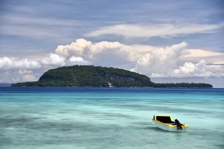
Espiritu Santo
My hope was to have a genuine diving experience in Santo, not be a repeat of the Port Vila deception. I chose a place 20km north of Luganville on the east coast road. It was in Turtle Bay, the site of the old Turtle Bay Airfield during the Pacific War, and close to some attractive blue holes.
Mavea Island. A dive on the north-western tip of Mavea Island offered crystal clear water and a decent reef, but the lack of fish life was still an issue. However, I did encounter a hawksbill sea turtle, a lone great barracuda, and a red snapper. A French couple with their young son shared the zodiac boat with me. During the interval time, the inflatable boat began to fill up with water in the back due to excess weight. The wife feared the worst and we wisely returned to base before it was too late! Just in the nick of time.
Shark Point. Morning came and I was alone with the South African dive guide for an outing to Shark Point, on the northeast side of Billota Island, 30 minutes away. A video I had seen earlier had confirmed the presence of silvertip sharks at the site. I was eager to see them, but instead, I saw a timid grey reef shark.
The water was an amazing cobalt blue. The reef was attractive and healthy, full of colour and was carved by numerous gullies. Out of the blue, a school of bigeye jacks (Caranx sexfasciatus) came and swirled around me for a minute and then disappeared into the sun, without further ado. It was an exhilarating dive with plenty of time to get some good shots. Schools of neon fusiliers (Pterocaesio tile), variable-lined fusiliers (Caesio varilineata) and scissor-tailed fusiliers (Caesio caerulaurea) made furtive appearances. The highlight was a small cloud of white-spotted surgeonfish (Acanthurus guttatus) playing hard to get.
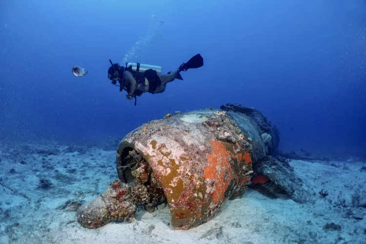
Vought F4U-1 Corsair. On my bucket list was a WWII plane wreck discovered in February 2020 at a depth of over 30m. It was a Vought F4U-1 Corsair fighter used in the Pacific War. It turned out that the Turtle Bay Airfield (Fighter 1) was constructed in late 1942 on a coconut plantation by the “Seabees,” also known as the 3rd Naval Construction Battalion of the US Navy. American units of the US Marine Corps (USMC) were based there in March and April of 1943, and VMF-213/VMF-214 pilots operated the F4U-1 Corsair for their raids on Guadalcanal in the Solomon Islands.
Fierce fighting took place against the Japanese. The F4U Corsair was a highly performing fighter plane at the time, with an 11 to 1 success rate against the Japanese Zero. The triple-bladed propeller plane had a so-called “bird cage” cockpit, located far back, behind the nose and behind the folding wings. This made landing tricky for pilots due to the lack of visibility. The Corsair was 10.26m in length, with a wingspan of 12.5m, and was armed with six .5-inch (12.7mm) M2 Browning machine guns, three in each outer wing.
A local named Johnny, the landowner of the site, knew the location of the wreck. However, on arrival at the site, there was no buoy to mark the wreck. “It’s around here…” said Johnny, gesturing with his hand. It was like looking for a needle in a haystack!
Losing hope for a while, I suggested that the dive guide go in first and have a look around. As luck would have it, just five minutes later, her safety sausage popped up at the surface. She had found the thick, algae-covered rope that led down to the wreck.
I jumped in. The visibility was fair. The whole aircraft was intact, resting on the white sand, facing south-southeast. The three blades of the propeller were missing, as the fighter had crashed shortly after take-off from Turtle Bay Airfield, probably due to engine failure or perhaps the loss of the propeller. The tail of the aircraft was broken in front of the tail rudder and twisted to the right. The cockpit glass was gone, as were the dashboard and instruments. The pilot’s seat was still there, empty.
Two friendly groupers were playing hide-and-seek around the nose of the plane. A silvery painted sweetlips (Diagramma pictum) zoomed towards me with curiosity. The maximum depth was 32.6m, with a dive time of 30 minutes. The water temperature was 30°C. I estimated the distance from the shore to be about 300m, next to the old airstrip.
SS President Coolidge. I did not dive Million $ Point, because I did not think much of it. As it was so renown, I did a dive on the SS President Coolidge instead. However, I was not impressed with this site as the visibility was poor and also because it was too deep. These were the two most famous dive sites in Santo, but far too touristy for me—unfortunately, another obvious “booby trap.”
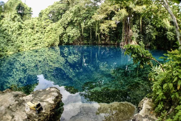
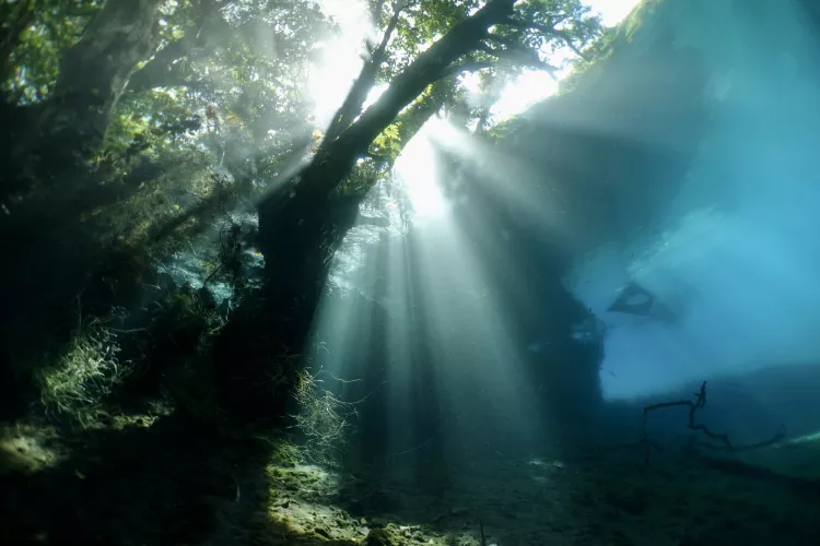
Matevulu Blue Hole. Last but not least on my wish list was the Matevulu Blue Hole, near the overgrown Turtle Bay Airfield. An entrance fee of VUV 1,000 was required in the honesty box. As it can turn into a public swimming pool for kids during the day, I chose to dive the site early in the morning before 8:00 on a Sunday. This is when all the locals go to church. At a maximum depth of 18.5m, this freshwater spring is the result of rainwater run-off seeping down underground from the highlands on the western side of Santo.
A shorty was recommended here, as the water temperature was 25°C. Amidst the sharply carved limestone rocks, the bottom was very silty, but there were beds of green moss and pretty underwater plants. What piqued my curiosity was the fish life, which included freshwater and, surprisingly, saltwater species too.
There were inquisitive little schools of spotted scats (Scatophagus argus), which were silver and square-shaped, with dark spots. Mangrove red snappers (Lutjanus argentimaculatus), which were silver with light bars and red fins, were common. Other species included the rock flagtail (Kuhlia rupestris) with black-tipped tail lobes. A school of vermiculate rabbitfish (Siganus vermiculatus) skimmed the bottom. I was astonished to meet three silver jacks or white trevally (Pseudocaranx dentex) with yellow fins and a prominent keel on the caudal peduncle.
Quite a few logs were found underwater, and there were a lot of roots and grasses along the banks of the blue hole. From Matevulu Blue Hole, a river flowed east and then south into Turtle Bay. Surfacing after a 55-minute dive, I noticed a dusky sleeper (Eleotris fusca) close to the edge of a muddy bank. Although I had heard that they might be present, I did not see any freshwater eels.
Endemic species and expeditions
Of the 49 freshwater species in Santo, ten species are endemic. There are also 917 species of marine fishes recorded in Santo, as of 2006. The ten largest coastal fish families are the Labridae (81 spp.) and Pomacentridae (81 spp.), Gobiidae (72 spp.), Serranidae (49 spp.), Apogonidae (37 spp.), Chaetodontidae (31 spp.), Acanthuridae (28 spp.), Blenniidae (25 spp.), Scaridae and Holocentridae (21 spp. each).
There have been numerous scientific expeditions to Vanuatu over the past 240 years. James Cook was the first to undertake one here (1768-1771), followed by the Frenchman Louis Antoine de Bougainville on La Boudeuse and L’Etoile in 1768.
The Whitney South Sea Expedition of the American Museum of Natural History took place in 1924. This was followed by the Oxford University Expedition in 1933 and the Royal Society Percy Sladen Expedition in 1971.
The most recent was the 2006 Santo Expedition, organised by the research institute for development (IRD) at the Museum d’Histoire Naturelle in Paris, with 233 participants of 24 nationalities, including 155 scientists. With an operational budget of US$1.1 million, and using the research vessel Alis, it covered all aspects of research on land and underwater, including cave diving explorations in the freshwater subterranean systems. A remarkable 572-page book, The Natural History of Santo, was published in 2011.
Final thoughts
Seen from the great blue yonder, Vanuatu certainly glistens like a snapshot of paradise. The reality is somewhat different. Either Port Vila or Luganville are tourist destinations in their own right, attracting high-income Australians and New Caledonians.
I got the impression that foreigners were seen as “walking banks.” Food and accommodation were by no means cheap, and the cost of living was high, even higher than in New Caledonia. A counter-effect of colonisation, I suppose.
But once you get off the tourist trail, you will find, like a breath of fresh air, how nice, friendly and hospitable the local Ni-Vanuatu are. All you have to do is sit down, entertain them with your time and share some stories. Doors will then be opened to you with a genuine smile of kindness and curiosity. ■
Sources:
Bouchet P, Le Guyador H, Pascal O. (eds) 2011. The Natural History of Santo. IRD Editions, Museum d’Histoire Naturelle.
Pacificwrecks.com
Stone P. (ed.) 1997. The Lady and the President: The Life and Loss of SS President Coolidge. Oceans Enterprises.
Vanuatu Tourism
Wikipedia.org


")


")


, Founder of Caladan Oceanic, along with Dr Osvaldo Ulloa, Director of the Instituto Milenio de Oceanografia (IMO), have completed the first-ever crewed dive to the deepest point of the Atacama Trench")

, on 27 October 1943")


 and Marcus Blatchford (right) decoing in Truk Lagoon, November 2019")
 burning on 15 September 1942")