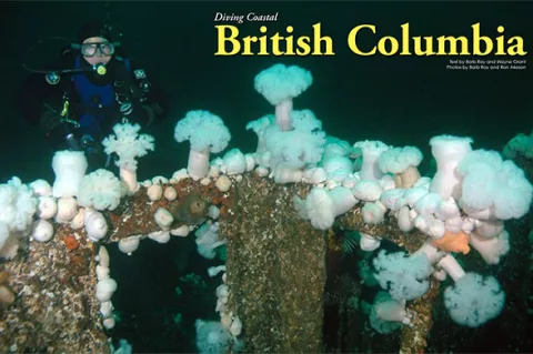
Referred to as the Salish Sea by local aboriginal people, the coastal inland waters stretching from Puget Sound to Johnstone Strait provide a vast and diverse area for scuba divers to explore. Not only are these temperate, nutrient-rich waters teeming with colorful marine critters of all sizes, visitors can enjoy underwater activities like photography, shipwrecks, deep walls and drift diving.


Contributed by
British Columbia (BC), located just above the US state of Washington, on the northwestern coast of North America, provides all of this and more, along with countless topside activities like fishing, skiing, hiking and great wildlife viewing. I have listed below a sample of some of these areas and what you might see when exploring them.
Howe Sound
This vast body of water is North America’s southernmost fjord, located northwest of Vancouver, between the lower mainland and the Sunshine Coast. Boat access is from Horseshoe Bay, at the end of Highway 1. From Horseshoe Bay, Highway 99 skirts around the eastern shoreline of Howe Sound to Squamish for 28 miles (45km), giving entry to several good shore dives.
Whytecliff Park and Porteau Cove are two of the favorites, providing plenty of parking and easy entry. Both are recreational in depth, but technical divers prefer Whytecliff Park for its protected cove (ideal for training) and its deep wall along the outer perimeter of the cove. Porteau Cove Provincial Marine Park is full of underwater enhancements identified with marker buoys, which include a tire reef, concrete blocks, pipes and several small boats. On many occasions, I have spotted lingcod, wolf eels, rockfish, and orange and white swimming anemones here.
Boat diving options include over a dozen good sites around Bowen and Gambier Islands, Pam Rocks and numerous other small islets scattered throughout the Sound. Huge cloud and boot sponges are seen at Christie Islet, but smaller invertebrates like swimming scallops, plumose anemones and nudibranchs reside in the shallows. Copper rockfish and young lingcod are also plentiful at Pam Rocks, with playful sea lions occasionally appearing around the divers during the winter months.
The HMCS Annapolis is Howe Sound’s newest wreck, sitting upright just off Gambier Island. At over 107m (350ft) in length, this ex-Canadian Navy vessel was scuttled in 2015 by the Artificial Reef Society of British Columbia (ARSBC). Divers can easily swim into the ship’s huge helicopter hangar, travel down covered walkways or peer into the engine room because the depth is all within recreational dive limits. I have always enjoyed the bridge where the captain once stood looking out over the bow. Although large diver access holes have been cut throughout the ship’s hull and decks for safe viewing, penetration is only recommended for those with proper training and equipment. Like any wreck in BC, you might be surprised at how much life resides on the outside of the ship!
When not diving, check out one of the many trails along Highway 99, go kayaking or take a Sea to Sky Gondola ride up the mountain in Squamish for a breathtaking view of the Sound! You will also find the 100-meter-long Sky Pilot Suspension Bridge at the top. For a step back into history, check out the Britannia Mine and spend a fun day with the family learning to pan for gold, touring through old coal rail tunnels and exploring the museum.
Lower Sunshine Coast
This part of the Sunshine Coast stretches about 110 miles along the Strait of Georgia, from Howe Sound to Desolation Sound, and is accessed via BC Ferries from Horseshoe Bay to Langdale (40 minutes sailing time) followed by a 30-minute drive north to the town of Sechelt. Within Sechelt Inlet is the wreck of the HMCS Chaudiere, a 366-foot (111m) Destroyer Escort, scuttled in 1992 by the ARSBC. Since then, the ship has transformed into a gigantic condo complex for juvenile fish, wolf eels and assorted invertebrates. To top it off, the ship is on its side and stretches from 60 to 130ft (18-39m) of water.
Tzoonie Narrows, also in Sechelt Inlet, is a fun drift dive complete with a garden of photographic invertebrates, rocky overhangs and flat sections where orange and white giant nudibranchs hunt for tube-dwelling anemones. The last time I dove here, my buddy and I encountered half a dozen 4-6ft (1-2m) dogfish (small sharks)—it was so exciting!
The site of Tuwanek can be accessed by boat or shore, and is great for photography and night diving, yielding wolf eels, nudibranchs, assorted anemones, crabs and rockfish. I always like to explore this site during the day, then return at night for another look because the critters are so different.
Skookumchuck Rapids is a breathtaking advanced dive with a collection of colorful white and pink anemones grouped together with purple sea stars and finger-like sponges, making it a photographer’s paradise. When the current is running at full tilt, massive amounts of water pour through the narrow channel, creating a cauldron of turmoil from the view above water. But during slack current, when the water slows or stops to change direction, this is when the divers jump in! Deeper sections underwater will portray entire boulders covered in red, green, yellow and orange sponges and anemones. I have found colorful rock greenlings and other rockfish resting at the bottom in the shallows near smaller boulders, ready to dart back to their shelter when the current once again picks up in speed.
Jervis Inlet, Narrows Inlet and Agamemnon Channel are especially good for boat diving. Technical and deep-range divers will love the deep walls of Agamemnon where huge red and pink gorgonian sea fans can be found among giant clusters of yellow cloud sponge. The motivation of photographing these unique fans is what encouraged me to take up technical diving. This in turn opened a whole new group of subjects for me.
When not diving, visitors can enjoy cultural kayaking tours, wildlife watching and mountain or trail hiking. Sechelt Inlet is a popular favorite for loading camping gear onto a kayak and paddling out for a few days. Don’t forget the snorkeling gear!
Upper Sunshine Coast
Continuing north on Highway 101 from Sechelt, Powell River can be reached by taking another BC ferry from Earls Cove to Saltery Bay (a 50-minute ride). Between Saltery Bay and Powell River, a diver can find Mermaid Cove (a shore dive) where a 9ft (3m) bronze mermaid welcomes all. Be sure to check out the base for a resident octopus. Just up the road is Octopus Hole, another easy shore dive, where one can find more octopi, orange and brown burrowing sea cucumbers, nudibranchs and sculpins.
Another interesting shore dive is the shallow wreckage of the Malahat, located at the old mill along a breakwater of ghost ships. The ship’s skeletal remains provide superb habitat for nesting lingcod, cabezon, greenlings and young wolf eels.
By boat, divers can access the MV Gulfstream, which sank in 1947 at Dinner Rock. This advanced wreck dive is in 125-155ft (38-47m) of water. The wall is steep but hosts abalone, lingcod, rockfish, cup corals, and huge white and orange plumose anemones.
When not diving, it is fun to visit Lund for sightseeing, walk along one of Powell River’s many beaches or launch kayaks at several calm beaches. I have heard recently that the ARSBC has been in negotiations to help the local community sink the concrete vessels at the mill for a future dive park, accessible by boat.
Port Hardy
This quiet fishing town is located at the northeastern end of Vancouver Island, opening to the Inside Passage and the Queen Charlotte Strait. Most of the diving is done from land-based resorts with fast boats.
Perhaps the most famous site is Browning Wall, located in Browning Passage on the southeastern side of Nigei Island. Divers will have difficulty finding a bare patch of rock at this current-fed site. Rest assured, however, all dives are conducted during slack current. Hordes of red, pink and orange soft coral flourish next to arm-length clusters of glove sponge, ruffled orange-peel nudibranchs and white-spotted rose anemones, with tiny shrimp living at their base. Macro photographers should keep an eye out for minute sea spiders, found covering some of the sea strawberry soft coral branches.
Seven Tree Island is another lush site flanking Nigei and where I have always found the illusive decorated warbonnets, mosshead warbonnets and colorful small fish. Barry Islet offers fields of miniature red, pink and white gorgonians and basket stars holding tight to them. Macro subjects at Dillon include purple-ringed topsnails, several species of nudibranchs and bright orange juvenile Puget Sound king crabs. Larger subjects at Dillon include octopi, ancient-looking ratfish and curious wolf eels.
The remains of the Themis can be found on the north side of Crocker Rock, with half of the ship in a forest of kelp and the rest draped over a reef. Wolf eels, octopi and seals are commonly spotted here, along with Puget Sound king crabs and beautiful sponges.
Weather permitting, divers will enjoy a day across the Strait exploring Slingsby Channel. The outer walls are excellent for photography, hosting an array of invertebrate life worthy of a large memory card! Turret Rock (aka Tremble Rock) is another site, located in the middle of Nakwakto Rapids. Recorded at speeds of 22 knots, the life found here is amazing! Huge clusters of unique Nakwakto gooseneck barnacles with red coloration and six-rayed white sea stars are a few to be found.
When not diving, visitors might enjoy paddling around in kayaks in some of the calmer coves or fishing for salmon. I personally like the wildlife viewing opportunities, commonly seeing black bears, dolphins, sea otters and eagles.
Campbell River
Campbell River stretches close to 15 miles (24km) along the mid-eastern coast of Vancouver Island, and is located north of Nanaimo. Ferry access is from Powell River to Comox or from Nanaimo, crossing at Horseshoe Bay or Tsawwassen on the mainland. Quadra Island lies parallel to Campbell River, with Discovery Passage separating them. Since this is a high current area, slack times must be followed and are well known by local dive operators.
In 1996, the ARSBC scuttled another retired warship, the HMCS Columbia, off Maud Island. The six mortar guns are very impressive and I have photographed large giant Pacific octopi next to and on the ship! Around Maud island is Seymour Narrows where whirlpools and standing waves form at peak flow. Anemones are everywhere underwater, as well as staghorn bryozoans, urchins, China and quillback rockfish, and orange tennis ball sponges.
Copper Cliffs offers a colorful wall, ledges and huge purple algae covered boulders. Rose sea stars, juvenile box crabs, red Irish lords, multitudes of tunicates and cup corals can be found here. Massive clusters of giant purple-plumed feather duster worms are everywhere at Steep Island and a carpet of pink and red strawberry anemones cover the bottom at Whiskey Point. On a single dive here, I counted four large Puget Sound king crabs! End-of-the-Road reminds me of a nursery for young octopi and sculpins hiding amongst a blanket of invertebrates.
If weather permits, a day excursion south to Mitlenatch Island to explore the wreck of the Capilano (which sank in 1915) is well worth a trip. The 120ft (36m) ship sits upright in 100-145 feet (30-43m), covered in a shroud of white plumose anemones. Lingcod, huge rockfish and cloud sponge also adorn the site.
In Coast Salish language, “Mitlenatch” means “calm water all around.” Due to the excessive number of nesting sea birds, Mitlenatch was designated a Provincial Nature Park in 1961. Otters, harbor seals, Steller and California sea lions love to lounge on smooth warm boulders along the eastern coast, and will often join divers underwater.
When not diving, visitors might want to participate in a snorkel float down the Campbell River to see salmon during their migration upstream from mid-July through early October.
Nootka Sound
Nootka Sound is located on the western side of central Vancouver Island. This rugged coastal area can be accessed by road from Gold River or Tahsis, both over an hour’s drive from Campbell River. The surrounding mountainous landscape and glacier-scarred valleys were created during the Pleistocene ice age, leaving behind deepwater crevasses throughout the Sound. Today, lush forests of Douglas fir and Western Hemlock (some towering to over 70m) thrive in the area.
Most of the diving is done in Nootka Inlet and the neighboring Esperanza Inlet, yielding exceptional life. On the outer edge of Nootka Sound at McQuinna Point, I explored a huge kelp bed with my buddy, just below Yuquot Lighthouse (built in 1911). For a while, we were surrounded by a dozen curious dogfish. Alas, we must have been boring to them as they disappeared as quickly as they appeared. Tiny proliferating anemones decorate the base of each kelp stalk and Tealia (mottled) anemones were the size of dinner plates! Yellow sponges, shiny orange sea squirts, painted greenlings and red Irish lords also thrived here. Instead of the usual ochre sea stars, there was a multitude of bat stars.
There are many exploratory sites in Nootka, some with kelp beds and others on deep pinnacles or in sheltered coves. It is easy to find walls or boulder-covered terrain with hiding octopi and wolf eels. These sites also host several species of rockfish, lingcod, sculpins and a few ratfish. Huge sections might be covered with strawberry anemones, scallops, nudibranchs, aggregated vase sponges, purple encrusting bryozoan and more huge anemones.
When not diving, visitors are encouraged to go for a paddle around the calm waters near Tahsis. Hiking, whale watching and salmon fishing are equally as fun.
Barkley Sound
Located within the boundaries of the Pacific Rim National Park Reserve on the western coast of Vancouver Island, Barkley Sound is a unique wild coast wonderland. Divers can access the area by boat from Port Alberni, via the narrow 25-mile-long (40km) Alberni Inlet, or by car down a 56-mile (89km) gravel logging road from Port Alberni to Bamfield. Diving is available year-round from several operators offering both day and multi-day excursions. With over 100 islands in the Broken Group alone, it’s easy to find a dive site, even if the weather is bad.
Chup Point is a good place for fish photography, usually yielding more than five species of rockfish on a single dive. Yellow and white dorids, orange-peel nudibranchs, frosted and opalescent nudibranchs can also be seen here.
I have always thought of Renate’s Reef, one of my favorites, as “Wolf Eel City” because of its numerous long gray residents of varying length and age. Octopi, china and tiger rockfish and medium-size lingcod also reside here.
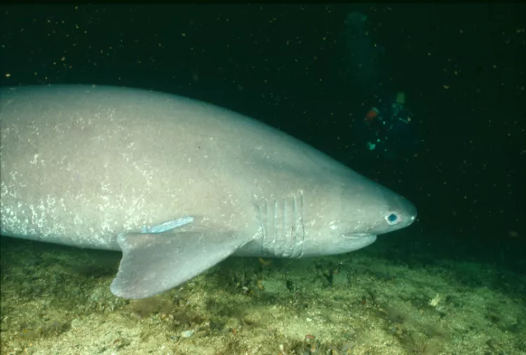
Sixgill shark sightings are possible at Tyler rock, although they are rare. But Barkley Sound is one of the regular places the sharks frequent in BC, and the dive operators will all have their choice spots. Plenty of ratfish, orange sea pens, octopi and sculpins can be seen between Tyler’s two submerged pinnacles when the sharks are not around.
Barkley Sound has several shipwrecks to explore: the Vanlene and the abandoned Chinese migrant ship scuttled as an artificial reef in 2003. Not much remains of the 473ft (142m) Vanlene since it went down in 1972 near Austin Island. I have spotted adult Puget Sound king crab, multi-colored sunflower stars, rockfish, California sea cucumbers and abalone to photograph. The Vanlene’s bow can be found in the shallows, but the rest of the ship unfolds over the rocks like a broken puzzle to over 100ft (30m) in depth. The migrant ship is approximately 100ft in length and sits upright in 95ft (28m) of water near Canoe Island in Sechart Channel. The hull and wheelhouse are easy to explore, with the majority of its marine residents growing on the outer hull and bow area.
When not diving, humpback and gray whale watching is popular, as are leisure paddling trips to take in the magnificent scenery and wildlife.
Nanaimo Area
Nanaimo is centrally located on the eastern side of Vancouver Island and acts as a hub for incoming mainland air and sea traffic. There are 8-12 excellent boat dives and several good shore dives to pick from.
Popular wrecks include the 366ft (111m) HMCS Saskatchewan, the 400ft (122m) HMCS Cape Breton and the 157ft (47m) North Sea Rescue Tug Rivtow Lion scuttled as artificial reefs. Technical and extended-range divers like to practice their skills in and on the two larger wrecks, while photographers and naturalists enjoy them all. Currents are not usually a problem, but better visibility usually occurs on a falling tide, especially during winter months.
Enormous white plumose anemones cascade down a sandstone wall dotted with bright pink crimson anemones on the northern side of Snake Island, along with red blood stars and orange finger sponges. I have also seen wolf eels out in the open and clusters of cloud sponge at deeper depths. Snorkeling with resident harbor seals is always fun during surface intervals here.
Orlebar Point, another steep wall on Gabriola Island, hosts an array of odd-shaped chimney sponges, tiger and quillback rockfish and an assortment of crustaceans. This shore-accessible site is also utilized by technical divers.
As for drift diving, there are two narrow passageways where the currents commonly reach eight knots at full flow. This in turn provides a rich environment for a multitude of invertebrate life to flourish. Both sites can be explored during slack. Dodd Narrows has brilliant giant green anemones and pink tipped anemones in the shallows, while yellow zoanthids, orange cup corals and small white anemones cover the boulders below. Gabriola Passage is equally as picturesque, hosting an array of red sea urchins, gray-encrusted lobed ascidians, cabezon fish, grunt sculpins and painted greenlings.
When not diving, sailing is one of the many fun activities to do. Malaspina Galleries (sandstone overhangs) and the aboriginal petroglyphs can be found on nearby Gabriola Island, or visitors might want to stroll along the water down an easy boardwalk downtown.
Chemainus Area and Porlier Pass
Porlier Pass, Trincomali Channel and Stuart Channel offer divers something different at each site. I was quite impressed with the historical wreck of the 190ft-long, duel paddle-wheel steamer Del Norte, which sank in 1868. Not much of the wreck remains, except for the ship’s two paddle-wheel bases with protruding spokes and a couple of boiler stacks with chunks of coal everywhere.
Another easy dive is the 737 plane near the town of Chemainus. This unique airframe sits on a stand in 70ft (21m). Currently, over 100 species have been identified living on the wreck by local diver and book author, Andy Lamb.
Wolf eels, basket stars, huge lingcod and rockfish are common in Porlier Pass at one of several wall dives, or around the wreck of the Point Gray.
Victoria, Sidney and Saanich Inlet
Victoria is the capital city of BC, located at the southern end of Vancouver Island, accessed by air or ferry from Tsawwassen to Swartz Bay (Sidney) or Port Angeles (WA) to Victoria.
Strong nutrient-rich currents support an assortment of large and small marine residents. From a photographer’s point of view, the marine biodiversity is enough to stagger the imagination. There are numerous shore and boat diving sites around the city, as well as Sidney and all along Saanich Inlet. One of the most popular shore spots is along the Ogden Point breakwater, five minutes from downtown Victoria. An assortment of rockfish, kelp greenlings, nudibranchs, perch and sea stars can be found. Octopi and wolf eels also enjoy the protection of the blocks for their dens. Several large reef balls have also been placed here to provide more habitats.
Race Rocks is located about three nautical miles from Pedder Bay in the Strait of Juan de Fuca, where great quantities of flowing water create a fast-paced high-energy advanced dive. This caldron of boiling turmoil supports a huge concentration of life, which is best explored during slack current. Pink and white clusters of soft corals, bunches of finger sponges and colorful nudibranchs share this underwater rocky terrain with lavender tinted coralline algae and overlapping leaves of ground-covering kelp. Multi-colored brooding anemones cover the lower portions of kelp stalks, resembling a garden of flowers.
The 175ft (52m) GB Church and the retired ex-naval ship HMCS Mackenzie are within minutes from Sidney. Both sit upright in relatively moderate current areas. Keep an eye out for nesting lingcod, rockfish, swimming scallops and an endless supply of invertebrates.
In conclusion
No matter where you begin your dive holiday, BC can provide a fun, relaxing experience for the whole family. BC Ferries connects to all of the above locations, and during peak summer months, it is advised to book your ferry travel well in advance, with reservations (www.bcferries.com) early. On the mainland, ferries can be accessed via Horseshoe Bay (heading to Nanaimo or the Sunshine Coast) or from Tsawwassen (Victoria or Nanaimo). When visiting Canada, you will need a passport and/or proof of citizenship.
Water temperature averages 46-55°F (7-13°C) throughout the year, requiring thick exposure protection (a drysuit). Many BC and Washington State dive stores and BC dive operators offer complete dive packages with accommodation. Gas mixtures of nitrox, trimix and argon are also available. So, enjoy your holiday, stay within your skill limits and have some fun in the northwest! ■